Squamish River could near a 1 in 50 year flood this week, its biggest since 2003
Loading the newest river reading…
The top of the province's forecast range is just under a 1 in 50 year flood, and the province says the river can go higher than its range. The middle forecast is a 1 in 10 to 1 in 20 year flood, still the biggest since 2003, near its peak from Wednesday night. The Upper Squamish Valley has no dikes and one road out. Most of town sits behind dikes. Live numbers, six charts and what to do before Tuesday night.
What does this mean for me?
Tap where you live or where you are going.
Most exposed Upper Squamish Valley. Highest risk. No dikes, and Squamish Valley Road is the only way in and out.
- Move animals, vehicles, trailers and feed off low ground in daylight on Tuesday. Aim to be done by mid afternoon.
- If being cut off would put you at risk (medical needs, small children, no supplies), leave in daylight on Tuesday. Do not count on leaving Wednesday. This is general advice, not an evacuation order.
- Otherwise, be ready to be cut off: three days of food, water, medicine and fuel, and charged phones.
- Alerts: sign up for SLRD Alert. Regional district: 1-800-298-7753.
Most exposed Paradise Valley. Exposed. The Cheakamus River is forecast to peak near 393 on Thursday afternoon. An evacuation alert was issued here in November 2021.
- Move animals, vehicles, trailers and feed off low ground in daylight on Tuesday.
- If being cut off would put you at risk, leave in daylight on Tuesday.
- Alerts: upper Paradise Valley, SLRD Alert. Lower Paradise Valley, Squamish Alert. Not sure? Sign up for both.
Take care Brackendale. Behind dikes, which lower the risk but do not remove it. The river gauge is named for Brackendale; that does not mean Brackendale is forecast to flood.
- Stay off dikes, riverbanks and gravel bars from Tuesday night to Friday. Banks can give way under fast water.
- Expect closed river trails and pooled water in low spots.
- Alerts: sign up for Squamish Alert.
- Flooding on your street: District public works, 604-815-6868, after hours 604-815-4040.
Take care Downtown and near the Mamquam. Behind dikes. The Mamquam River is forecast to peak near 358 late Wednesday, 83% of its record.
- Clear leaves from the storm drains near your home before the heavy rain, never in moving water.
- Never drive through water on a road. You cannot see how deep it is.
- Stay off dikes and riverbanks from Tuesday night to Friday.
- Flooding on your street: District public works, 604-815-6868, after hours 604-815-4040.
Take care Near the Stawamus or a small creek. No forecast. The province does not publish one for these. Small, steep creeks rise and fall within hours.
- Stay away from creek banks during the heaviest rain, Tuesday into Wednesday night.
- Clear storm drains and culverts near your home before the rain, never in moving water.
- Alerts: sign up for Squamish Alert.
Lower risk Higher ground (Garibaldi Highlands, Valleycliffe). The river is not your risk. The drive, blocked storm drains and power cuts are.
- Driving Wednesday or Thursday: check DriveBC first, or call 1-800-550-4997.
- Clear the storm drains near your home before the rain.
- Power out or a line down: BC Hydro, 1-800-224-9376.
- Thursday school: any closure is posted by 7 a.m. at sd48seatosky.org.
Take care Squamish Nation communities. Several Squamish Nation reserves sit beside these rivers. The Nation runs its own alert system for members.
- Check the Nation's own channels for its updates.
- Stay off riverbanks and gravel bars from Tuesday night to Friday.
Live: river, forecast and alerts
Loading the newest readings…
Email me if this changes
One email when the province issues a Flood Warning or ends its notice, the regional district lists an evacuation alert or order, or the forecast peak moves by 10% or more. Nothing else.
We email a link to confirm first. These do not replace official alerts: also sign up for SLRD Alert or Squamish Alert.
The short version
- Who is at risk: the Upper Squamish Valley, the rural valley along Squamish Valley Road north of town. It has no dikes and one road in and out. Paradise Valley is also exposed.
- Do now: if you are on low ground in the Upper Squamish Valley or Paradise Valley, move animals, vehicles, trailers and feed in daylight on Tuesday. Aim to be done by mid afternoon, well before dark.
- In town: most of town sits behind dikes, which lower the risk but do not remove it. On higher ground, like Garibaldi Highlands or Valleycliffe, the river is not your risk: the drive, blocked storm drains and power cuts are. Expect pooled water on roads and closed river trails, and stay off dikes and riverbanks Wednesday to Friday.
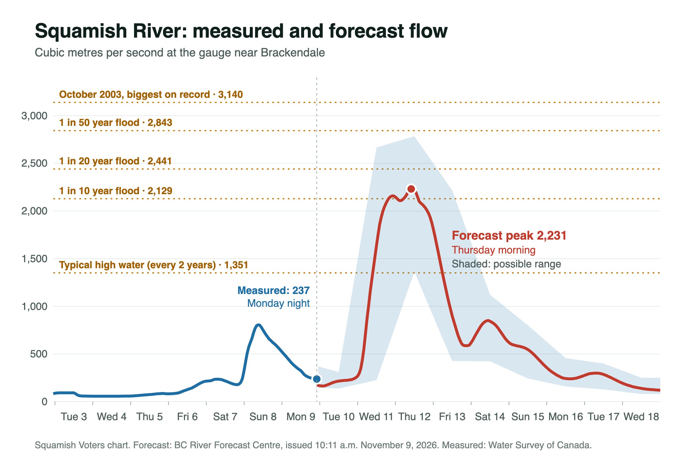
- How big: the province's river model has the Squamish River peaking near 2,231 cubic metres per second at the gauge near Brackendale. On the province's own scale that is between a 1 in 10 and a 1 in 20 year flood, and it would be the highest flow since the October 2003 flood.
- A way to picture it: the middle forecast is about 10% more water than the January 2024 high water. The top of the forecast range is closer to the 2003 flood than to 2024.
- How bad it could get: the top of the range is 2,784, just under a 1 in 50 year flood (2,843). The province says the real flow can land above its range.
- How mild it could be: the bottom of the range is about 1,360, the kind of high water the river sees every second year.
- Official status, late Monday night: the province has a Flood Watch out, which means flooding is possible, not certain. We found no evacuation alerts or orders on the regional district's list. The live panel above checks both every five minutes.
- Highway, schools and Remembrance Day: Highway 99 was open late Monday night, but Environment Canada warns some roads may become impassable, so check DriveBC before you drive Wednesday or Thursday. Wednesday is a school holiday. For Thursday, the school district posts any closure by 7 a.m. at sd48seatosky.org. The outdoor ceremony at the cenotaph is just before 11 a.m. Wednesday, in the heaviest rain, and we have not seen any change announced.
The timeline. This is the province's forecast for the Squamish River:
- Monday, 10 p.m.: the river was at 237 and falling. It is calm before the rain.
- Tuesday, November 10: heavy rain starts, but the river stays low most of the day, around 200 to 300.
- Overnight Tuesday into Wednesday: the river starts climbing fast.
- Wednesday morning, about 6 a.m.: past 1,000 and still rising quickly. Wednesday is Remembrance Day.
- Wednesday afternoon, about 4 p.m.: past 2,000.
- Wednesday evening, about 7 p.m.: past the 1 in 10 year mark of 2,129, and already within about 4% of the peak. It may ease slightly overnight, then rise again Thursday morning.
- Thursday, November 12, morning: the peak, near 2,231.
- The high edge of the forecast band crosses the 1 in 10 year mark by about 6 a.m. Wednesday, so a higher and earlier peak is possible.
- Thursday evening: still around 2,000.
- Friday morning: back under 1,300 and falling.
- Saturday: a second, smaller bump near 850 from Friday's rain.
The river is forecast to stay above 2,000 for about 28 hours, from Wednesday afternoon to Thursday evening. Do not read "peak Thursday morning" as having until Thursday: the river is forecast to be almost as high by Wednesday evening.
The live panel near the top of this page shows the newest river reading and the newest forecast, every five minutes. The numbers in the story itself are from the forecast below.
You can see the province's own chart for the Squamish River here. It was issued at 10:11 a.m. Monday, November 9. The province reruns it at least once a day, so check the time stamp on the chart. River numbers in this story come from that forecast unless we say otherwise. Rain and freezing level numbers come from the Open-Meteo weather model.
One caution: these numbers are flow at the gauge. Flow does not say exactly which land floods. That depends on the water level at each spot, log jams and banks giving way.
Who is most exposed
- Upper Squamish Valley. This is the rural valley north of Brackendale, not the town. The homes, farms and campgrounds along Squamish Valley Road have no dikes. The regional district's 2018 flood study maps large parts of the valley floor under water in a 1 in 50 year flood. Squamish Valley Road is the only road in and out.
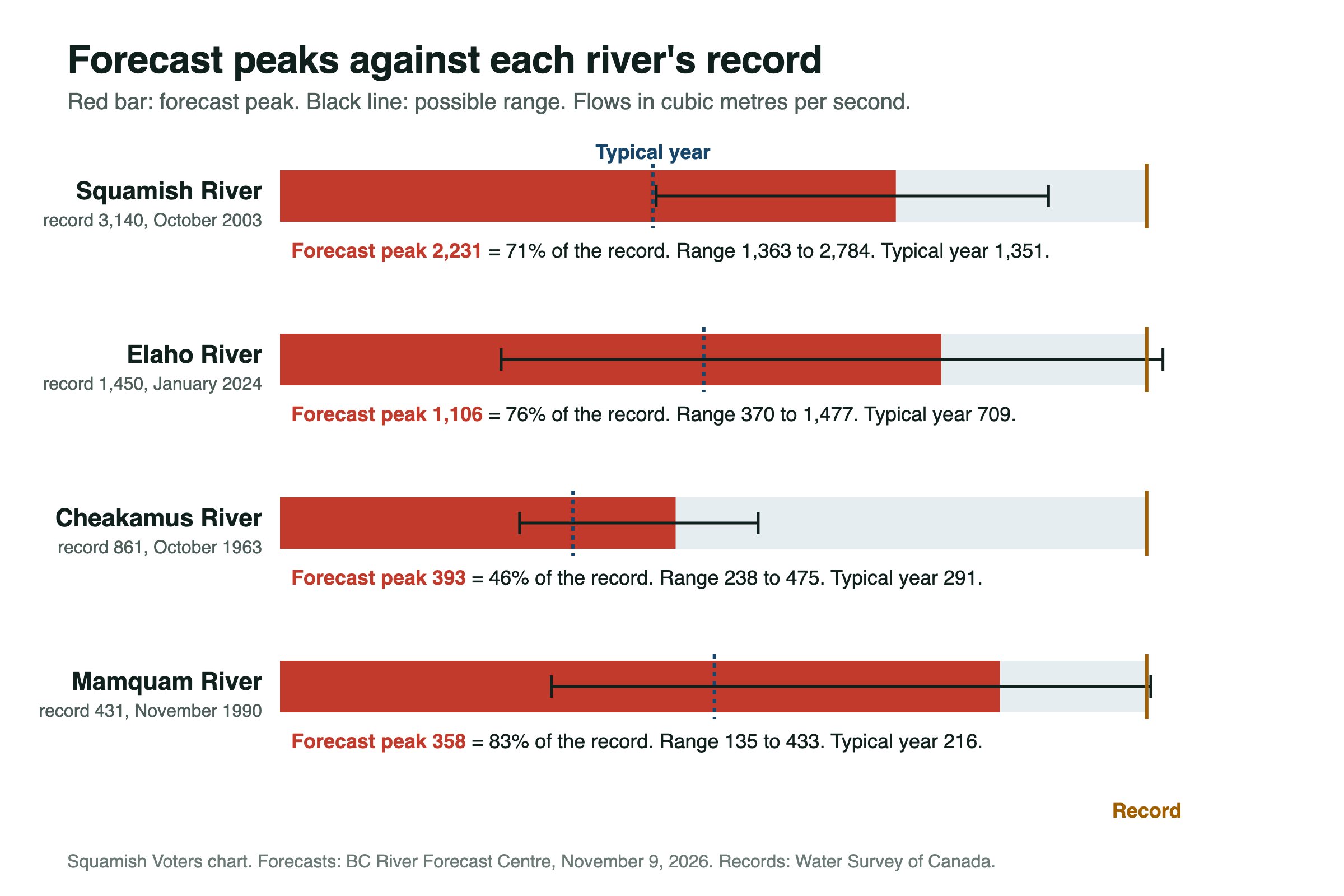
- Paradise Valley. The Cheakamus River is forecast to peak near 393 on Thursday afternoon, about 1.4 times its typical yearly peak of 291 and 46% of its record of 861, set in 1963. An evacuation alert was issued for Paradise Valley during the November 2021 storm.
- Squamish town, including Brackendale. The gauge is named for Brackendale because it sits on the river nearby. That does not mean Brackendale is forecast to flood. The District keeps raising the town's dikes under its flood plan. We track that work on our flood protection page. High water still closes trails, floods low spots and makes riverbanks dangerous.
- Mamquam River. Forecast to peak near 358 late Wednesday. That is 83% of its record of 431, set in 1990, and the top of its forecast range is 433, a hair over the record.
- Elaho River. Forecast to peak near 1,106 Wednesday afternoon. That is 76% of its record of 1,450, set in January 2024, and the top of its forecast range is 1,477, also over the record. The Elaho is forecast lower than in January 2024 while the Squamish is forecast higher, which would mean more of the water comes from the other creeks and rivers along the valley this time.
- Stawamus River and small creeks. The province does not publish a forecast for these. Small, steep creeks rise and fall within hours, and the Flood Watch says they are especially sensitive.
- Squamish Nation communities. Several Squamish Nation reserves sit beside these rivers. The Nation runs its own alert system for members. Check the Nation's channels for its updates.
What to do
If you live in the Upper Squamish Valley or Paradise Valley:
- Move animals, trailers, vehicles, feed and equipment off low ground in daylight on Tuesday. The river is forecast to start climbing overnight Tuesday.
- If being cut off would put you at risk, leave in daylight on Tuesday. That means medical needs, small children or no supplies. Squamish Valley Road is the only way out and can flood before your property does. Do not count on leaving Wednesday. This is not an evacuation order. Only the regional district can issue one, and this is general preparedness advice.
- If an evacuation order is issued, leave at once.
- Otherwise, be ready to be cut off. Have three days of food, water, medicine and fuel, and charge your phones. Power and internet often go out up the valley.
- Sign up for alerts now. Upper Squamish Valley and upper Paradise Valley: SLRD Alert. Town and lower Paradise Valley: Squamish Alert. If you are not sure which covers you, sign up for both.
- Know the two evacuation words. An evacuation alert means be ready to leave. An evacuation order means leave now.
Phone numbers, in case the internet is down:
- Emergency: 911
- Squamish Lillooet Regional District (handles the Upper Squamish Valley and upper Paradise Valley): 1-800-298-7753. We could not find any announced place for livestock. Call before you load the trailer.
- District of Squamish public works, for flooding in town: 604-815-6868, after hours 604-815-4040
- DriveBC road reports: 1-800-550-4997
- BC Hydro, power out or a line down: 1-800-224-9376
Highway, schools, power and Remembrance Day, as of late Monday night:
- Highway 99: no incidents or closures between Horseshoe Bay and Whistler on DriveBC. Live status is on our Today page.
- Schools: Wednesday is a holiday. For Thursday, the Sea to Sky School District says schools stay open unless a closure is announced, and families are told by 7 a.m. Check sd48seatosky.org.
- Power: heavy rain and wind bring outages. The outage map is at bchydro.com.
- Remembrance Day: details of the ceremony. Check with the Legion for any change.
For everyone:
- Never drive through water on a road. You cannot see how deep it is or whether the road is still there.
- Stay off riverbanks, dike edges and gravel bars from Tuesday night to Friday. Banks can give way under fast water.
- Clear leaves from the storm drains near your home before the heavy rain, never in moving water.
- Follow the official sources. The regional district's emergency page is slrd.bc.ca/emergency-program. The District of Squamish's is squamish.ca. Evacuation alerts and orders across BC are on EmergencyInfoBC. The province's flood guide is at PreparedBC.
How big is 2,231?
River flow is measured in cubic metres of water passing the gauge each second. These are the flood sizes the BC River Forecast Centre uses for the Squamish River near Brackendale:
- Every second year: 1,351
- 1 in 5 year flood: 1,809
- 1 in 10 year flood: 2,129
- 1 in 20 year flood: 2,441
- 1 in 50 year flood: 2,843
- 1 in 100 year flood: 3,137
- October 2003, the biggest on record: 3,140
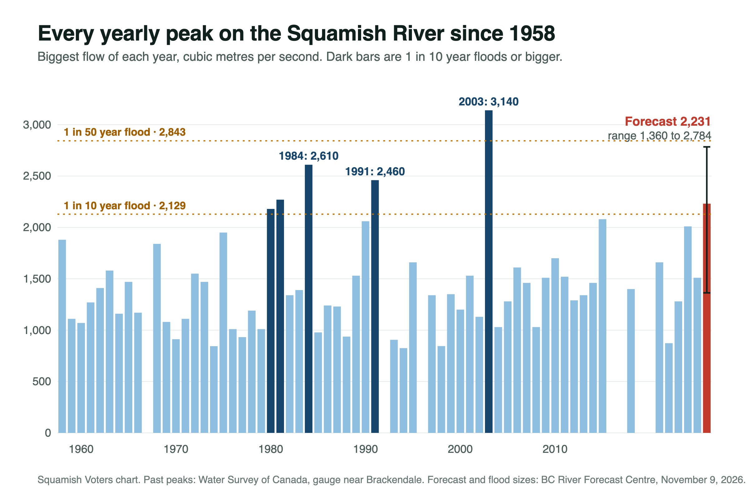
The middle forecast of 2,231 is past the 1 in 10 year mark. The top of the range, 2,784, is 59 short of the 1 in 50 year mark.
The ten biggest floods on record. The gauge has 61 published yearly peaks going back to 1958, from Water Survey of Canada. Seven years (1967, 1992, 1996, 2016, 2017, 2019 and 2020) have no published peak flow. For 2016, the recorded water level suggests a peak of about 2,000, which would put it on this list:
- 1. October 18, 2003: 3,140
- 2. October 8, 1984: 2,610
- 3. August 30, 1991: 2,460
- 4. November 1, 1981: 2,270
- 5. December 27, 1980: 2,180
- 6. September 20, 2015: 2,080
- 7. November 12, 1990: 2,060
- 8. January 30, 2024: 2,010
- 9. November 5, 1975: 1,950
- 10. October 12, 1958: 1,880
Where this storm would land on that list:
- Middle forecast, 2,231: fifth biggest of the 61 recorded yearly peaks, and the biggest since 2003. These are Water Survey of Canada's instantaneous yearly peaks, the same kind of number as the hourly forecast.
- Top of the range, 2,784: second only to 2003.
- Bottom of the range, about 1,360: an ordinary year. The river peaked higher than that in 2021 (1,660) and last December (1,510).
Nine of the ten biggest floods came between late August and December. Only five years on record have passed the 1 in 10 year mark of 2,129: 1980, 1981, 1984, 1991 and 2003. None since. A "1 in 10 year flood" does not mean it comes every ten years. It means a one in ten chance in any single year.
Seeing high water? Send us a photo
Photos of the river, Squamish Valley Road, trails or streets, with where and when you took them. We check each one before it goes up. Never go near the water to get a picture.
What these flows did last time
Flow at the gauge is only part of the story. This is what happened on the ground at similar or bigger flows, from news reports at the time:
- January 30, 2024, about 2,010: the province had a Flood Warning out for the Squamish River, and CTV News reported that floodwaters covered Squamish Valley Road. This week's middle forecast is about 10% more water than that.
- Late 2021: on November 15, with the worst of the water on the Cheakamus, the regional district put 35 properties in Upper Paradise Valley, along Paradise Valley Road and Mistys Lane, on evacuation alert, and BC Hydro issued a spill notice for the Cheakamus Dam (Squamish Reporter). The Squamish River's own 2021 peak, about 1,660, came later, on December 2. The Cheakamus is forecast to peak near 393 this week.
- October 2003, 3,140, the record: Squamish ordered about 100 people out of their homes, and about 200 more left the next day. The report did not say which neighbourhoods. BC Hydro opened the flood gates at the Daisy Lake Reservoir, and a river flooded its banks and spilled into town, CBC reported (CBC News). This week's top of the range, 2,784, is about 89% of that flow.
What the regional district says about floods this size. Its summary of the 2018 Upper Squamish flood study says: "At the 50-year flood event and above, most of the valley floor is flooded, with typical depths of 1 to 2 m within the inundated area." It adds that much of that water would be "dangerous for most to all people" (regional district). This week's middle forecast is below that 50 year size. The top of the range is just under it.
Were you there in 2024 or 2003? We could not find reports of exactly which stretches of road and which fields went under. If you know, send us a tip and we will add it.
The rain behind it
- Environment Canada's warning: 120 to 160 mm in Squamish from early Tuesday to Wednesday night, possibly more, with moderate rain into Thursday morning.
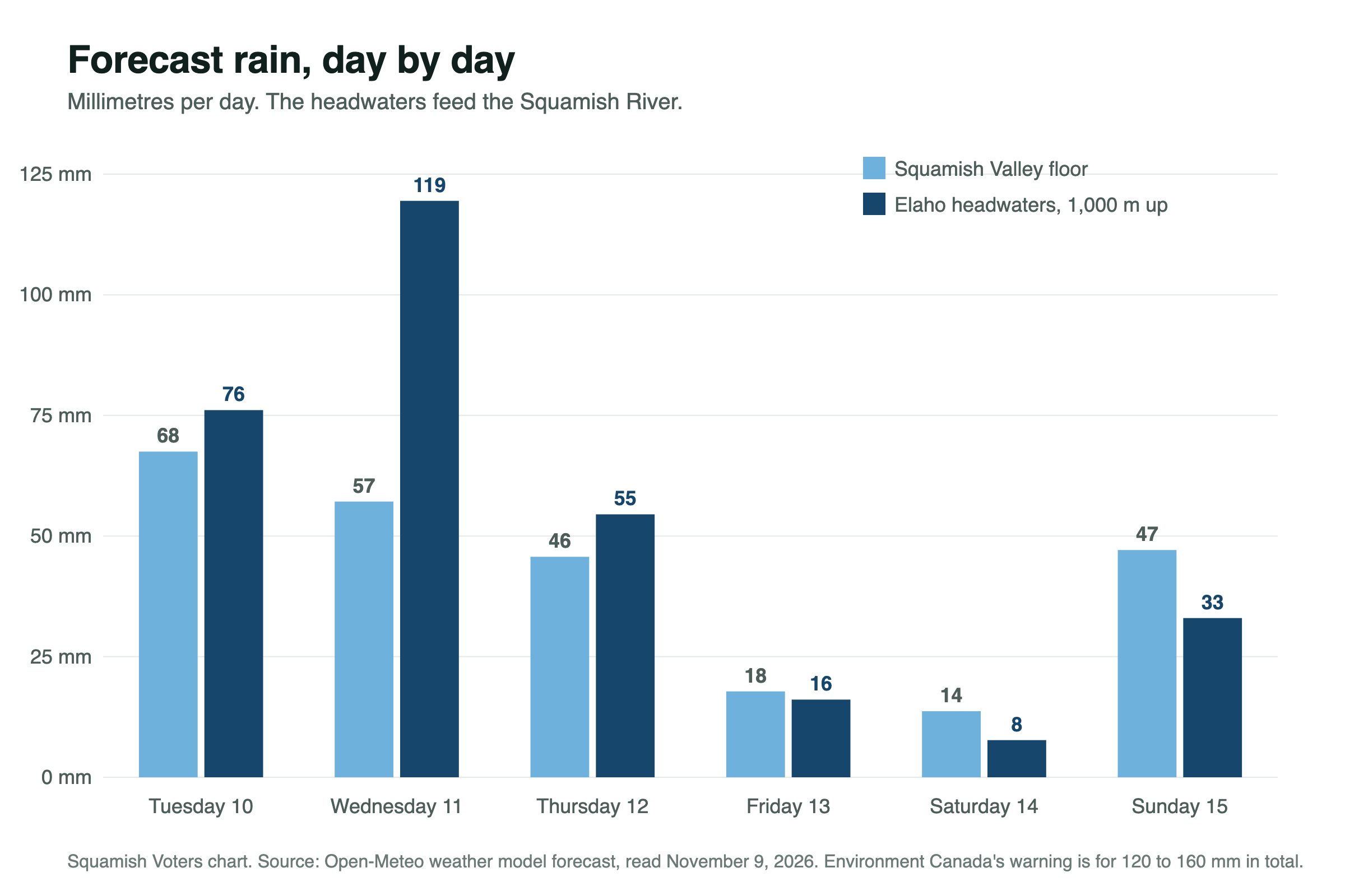
- The mountains get more. The Open-Meteo weather model puts about 76 mm on the Elaho headwaters Tuesday, 119 mm Wednesday and 55 mm Thursday. That is about 250 mm in three days on the ground that feeds the river.
- The valley floor: about 68 mm Tuesday, 57 mm Wednesday and 46 mm Thursday in the same model.
- It follows a wet week. The same model puts about 156 mm on the headwaters in the seven days before this storm.
It keeps raining Friday. Why does the river peak Thursday?
A river does not peak when the rain stops. It peaks after the heaviest and warmest rain.
- Tuesday and Wednesday are the big days. Rain on the headwaters drops by half on Thursday and to under 20 mm on Friday.
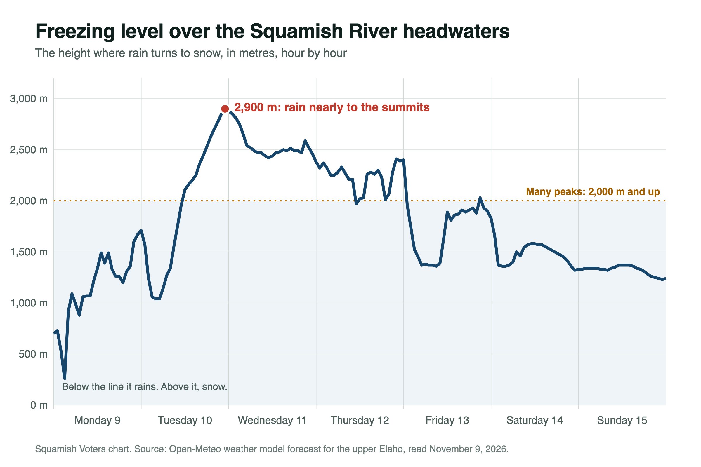
- Those days are also warm. The freezing level is forecast to climb to about 2,900 metres. That is above most of the peaks, so it rains on nearly the whole watershed instead of snowing on the top half. The province's Flood Watch also warns of melt from the shallow early snowpack.
- The river lags the rain. The Elaho is forecast to peak Wednesday afternoon. Its water reaches Brackendale within hours and drives the Wednesday evening rise. Continued rain then holds the river up into Thursday.
- Thursday's rain is lighter. Once the rain eases, less water is arriving than the river is carrying away, so it falls even though it is still raining. This watershed is steep and rocky and drains in about a day.
- Friday is colder. The freezing level falls to roughly 1,400 metres on Friday morning, so the upper half of the watershed gets snow, and snow stays on the mountain.
One thing to watch: forecasts disagree about how much rain falls Friday. If it comes in wetter and warmer, Saturday's second bump would be bigger than forecast, on ground that is already soaked.
The ground and the water table
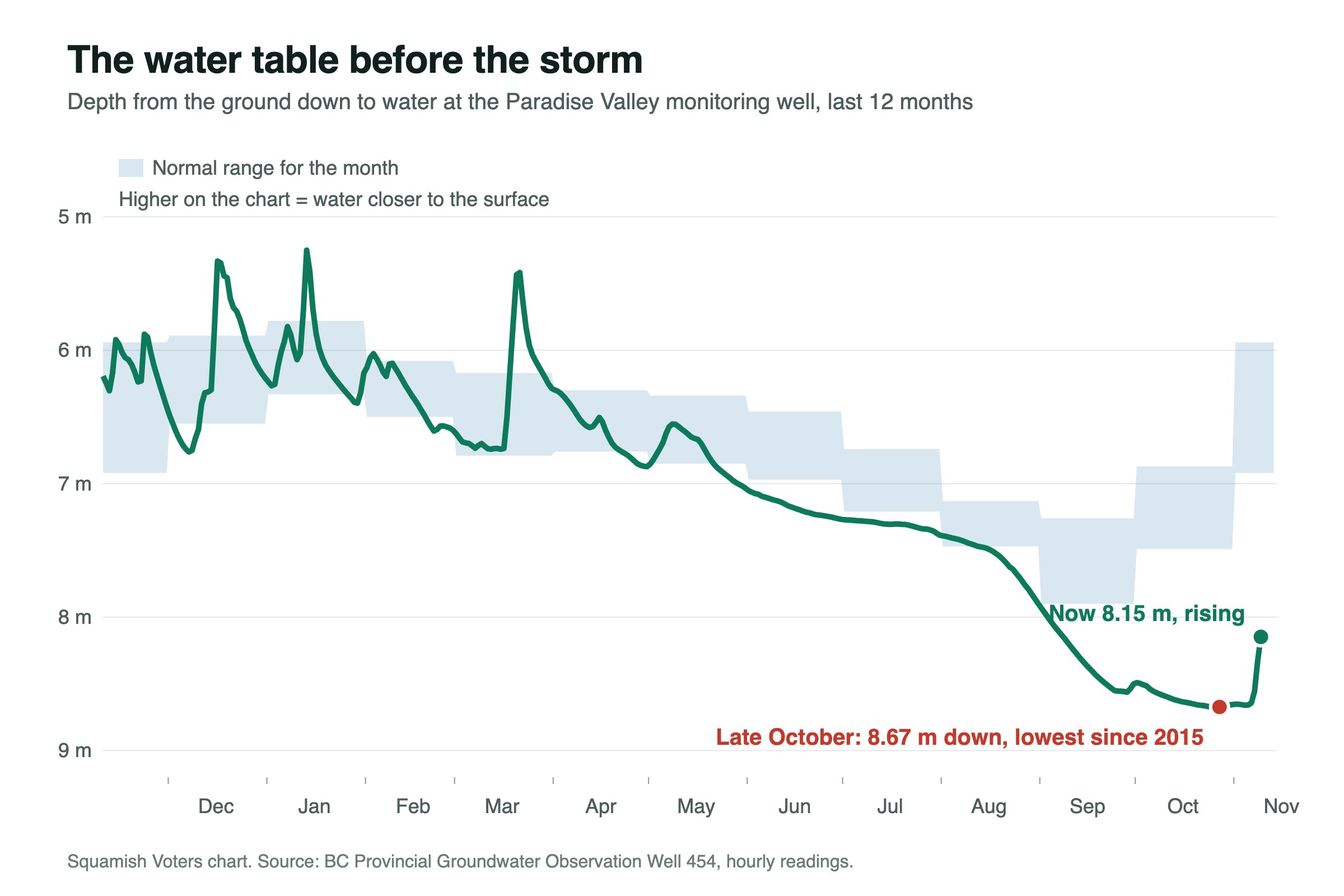
Until last week it had been a dry fall. A provincial groundwater monitoring well on Paradise Valley Road hit its lowest level since readings began in 2015 at the end of October: 8.67 metres below the ground.
Then the rain came. The Open-Meteo weather model puts about 156 mm on the Squamish River headwaters in the last seven days, and the Squamish River briefly reached about 800 on Sunday. The well has risen half a metre in a week and is still well below normal for November.
What that means: this one well only tells us about Paradise Valley, and it says the ground there started this storm unusually dry underneath. It cannot tell us about the Upper Squamish Valley. As a general rule, the water table in river gravels rises with the river, so low ground and old channels beside a river can get wet before any water comes over the banks.
Where the flood call comes from
When the District of Squamish or the regional district says there might be a flood, they are passing on a notice from the BC River Forecast Centre. The province builds it in four steps:
- Rain forecast. Weather models say how much rain lands on the mountains, hour by hour.
- Freezing level and snow. Warm storms rain on the whole watershed and melt snow. Cold storms leave snow up high.
- River model. The rain, the melt and the current river flow go into a model that predicts flow at each gauge for ten days.
- Compare with past floods. The predicted peak is compared with flood sizes, and one of three notices goes out.
The three notices, from mildest to most serious:
- High Streamflow Advisory: rivers rising fast, no major flooding expected.
- Flood Watch: rivers may reach or go over the top of their banks.
- Flood Warning: rivers are over their banks, or will be very soon.
Squamish is under the middle one. The province upgraded the South Coast, including Howe Sound and the Sea to Sky, to a Flood Watch at 12:36 p.m. Monday.
What agencies and other outlets are saying
Here is how the river forecast sits beside what agencies and other news outlets have said so far:
- Environment Canada has an orange rainfall warning for Squamish to Whistler: 120 to 160 mm, possibly more, with flooding likely and some roads possibly impassable. See the warning.
- The province's Flood Watch covers the whole South Coast and Vancouver Island in general words. It says modelling shows "the potential for flows in the 5-year to 10-year range, or higher, in areas".
- The Squamish Chief and North Shore News have reported the rainfall warning.
The bulletin covers the whole coast, so it does not name single rivers. The forecast for each river sits one layer deeper on the province's website, as a chart for each gauge. For the Squamish River, that chart falls in the "or higher" part of the bulletin's line: the middle forecast is over the 1 in 10 year mark, and the top of the range is close to 1 in 50.
What could change
- The range is wide. The forecast runs from about 1,360 to 2,784. The province says the real flow can even land outside that range.
- It will be updated. The province reruns the forecast at least once a day. If the storm tracks north or south, or the freezing level changes, the peak moves with it.
- A Flood Warning would be the next step. If the province issues one for the Squamish River, flooding is expected, not just possible.
We will update this story when the province issues a new forecast.