Squamish Valley Road washed out, upper valley cut off. When it could reopen
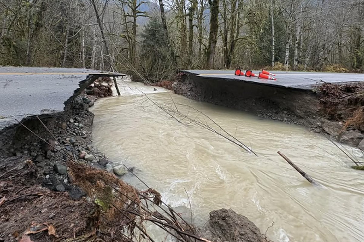
The river tore Squamish Valley Road apart about 5 km past Fergie's, and there is now no way in or out of the upper valley. The road crew on site says it will stay closed for a few days, and is telling people up there to decide now whether to stay or leave.
The upper valley is cut off
A resident posted photos Friday to the Cheekye, Paradise and Squamish Valley community board showing Squamish Valley Road torn away by the river about 650 metres past the smiley face, roughly 5 km past Fergie's. Brown water runs straight through where the pavement was, and the far side ends in a broken edge with traffic cones on it.
The road is the only way in. With it gone, everyone past that point, homes, farms, campgrounds and the forest roads beyond, has no road in or out.
- Emergency in the upper valley: call 911
- Need medical help, mobility help or a ride out: regional district emergency centre, 604-384-7357
- Squamish Nation members: flood line 604-982-9938, 24 hours
What officials say so far: DriveBC, updated 10:18 a.m. Friday, lists Squamish Valley Road as closed by flooding from the 3 km mark to north of the Pilchuck Creek bridge. The regional district's flood page says it is aware of "multiple flood impacts to roads" in the Squamish Valley and Paradise Valley. Neither has named the washout yet.
When it could reopen
The road crew says a few days. Miller Capilano, the contractor that maintains the province's roads in the Squamish area, is on site assessing the washout, a resident relayed in a valley group chat Friday morning. The crew told people the road will be closed for a few days, and that everyone in the upper valley should decide now whether they are staying or leaving. Even once the water is gone, there will be no way in or out until the road is repaired.
If you want to leave and need help getting out, call the regional district emergency centre, 604-384-7357. If you stay, plan for several days with no road: food, water, medication, fuel and a way to charge your phone.
No official reopening date has been posted yet. Here is what has to happen first.
- The water has to drop. A flooded road opens again when the water goes down. A washed out road does not: crews have to rebuild the ground under it, and they cannot start while the river is still running through the gap.
- Then a crew builds a temporary crossing. Usually that means fill, rock and a culvert, or a temporary bridge, often one lane at first. The permanent repair comes later.
- The weather may stall it. The province's forecast has the Squamish River falling to about 200 by Saturday, which could give crews a first look. Then about 46 mm of rain is expected Sunday, with the river rising again to about 440, possibly 600.
The last time this happened in the valley: on Aug. 6, 2025, a washout took out the crossing at Mud Creek, 21 km up the valley on the forest road. A temporary crossing went in on Aug. 20, two weeks later, and at first it was only for industrial and commercial users (Squamish Nation notice).
How that compares: the crew's few days is quicker than the two weeks Mud Creek took, which fits a crew already on site on a main paved road. Sunday's rain is the biggest risk to that timeline: if the river comes back up, work at the gap may have to stop. Treat a few days as the best case, and plan for longer.
Where the first real answer will come from: DriveBC, next update 10:15 a.m. Saturday, and the regional district's flood page. We will update this story when either gives a date.
Thursday's flood in short
- The people: close to 40 Squamish Nation members in the Squamish Valley have been evacuated, the Nation said Thursday. Its team went door to door, including to anyone who could be cut off if Fergie's Bridge, a different Squamish Valley Road crossing from the closed Pilchuck bridge, has to close. The Squamish Chief reports evacuees are being given a place to stay and care. The Nation asks for care around Lewis Drive and Moody Lane, where the water was still rising.
- Paradise Valley: the District of Squamish has a shelter in place advisory for the mapped area of Paradise Valley, including the Sunwolf Lodge and Cheekye Ranch area. If you can safely stay where you are, stay. If your spot starts to flood, go to higher ground. The map is linked from the regional district's flood notice. Questions: District emergency centre, 778-655-3020.
- The rivers peaked overnight and Thursday morning and are falling slowly.
- Rain returns Friday, with more on Sunday, but colder, and the province's river forecast stays far below this week's peak. Details below.
When Paradise Valley could reopen
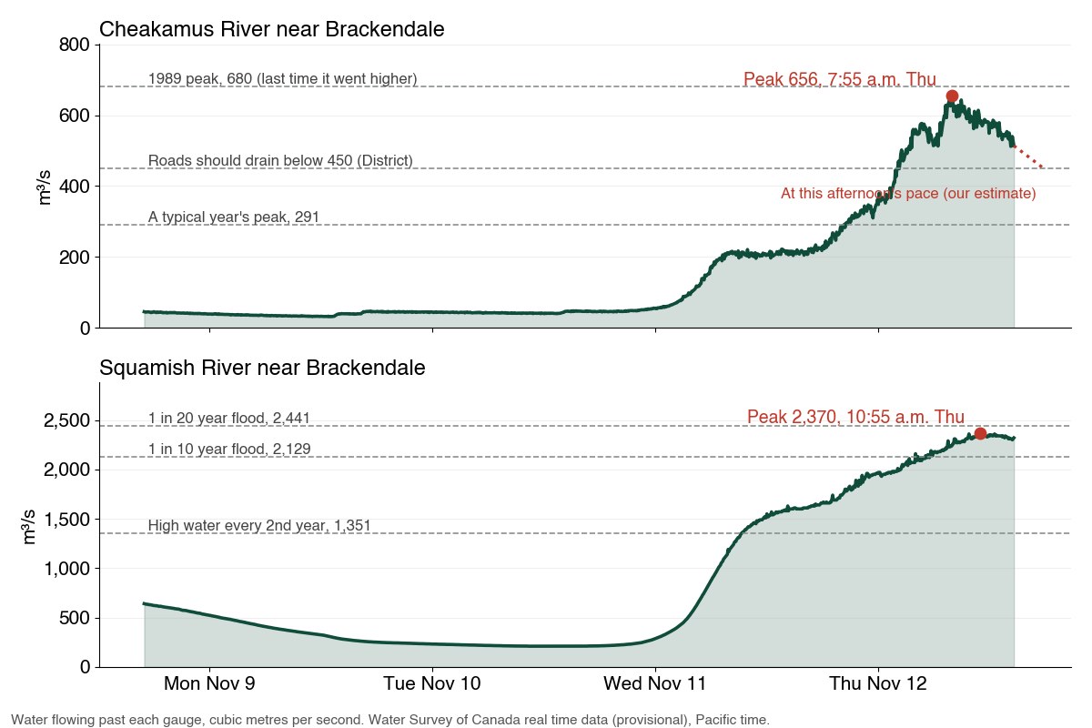
The District gave one number to watch for Paradise Valley. "Once the river level at the Water Survey of Canada Brackendale gauge is below 450 cubic metres per second, road flooding should cease," said Alex Preston, the District's public information officer.
Which gauge? There are two Water Survey gauges near Brackendale, one on the Squamish and one on the Cheakamus. The District did not say which. We read it as the Cheakamus gauge, for two reasons: the Cheakamus is the river that runs past Paradise Valley, and BC Hydro's own flow notices call that gauge (08GA043) "WSC's Brackendale Gauge". The Squamish gauge is running in the thousands this week, so 450 only makes sense for the Cheakamus.
Where it stands:
- Peak: 656 at 7:55 a.m. Thursday
- 11:35 a.m.: 580
- 2:35 p.m.: 514, roughly 60 to 75 above the line
Our rough estimate: this evening at the earliest, somewhere around 6 to 10 p.m. Thursday. In the early afternoon it fell about 20 an hour, which would cross 450 around 6 p.m. Through the late morning it fell only about 12 an hour, which would take until about 10 p.m. The readings jump up and down by about 20 every few minutes, rivers rarely fall in a straight line, and BC Hydro controls part of this river through the Cheakamus Dam, so treat that as a rough guide. No one has announced a reopening time, and the District said flooding should end, not that the road will open at once. Watch the gauge live, and check DriveBC before you go.
Squamish Valley Road is a different river. It floods from the Squamish River, not the Cheakamus, so the 450 number does not apply, and no one has said when it could reopen. DriveBC lists it as closed by flooding from the 3 km mark to north of the Pilchuck Creek bridge. The province's forecast has the Squamish falling under 1,000 by Friday morning. On Paradise Valley Road, the Bailey bridge is the only road access to the homes, businesses and services on the north side, the regional district says.
The dam. BC Hydro's release from the Cheakamus Dam at Daisy Lake peaked about 5 a.m. Thursday, the District said. BC Hydro is cutting it slowly through the day, with two goals: make room in the reservoir for the next storm, and get the river back under its banks so the road can reopen.
What the weekend brings
The rainfall warning ended Thursday morning, and the District and the Nation said heavy rain is no longer expected through Friday. The BC River Forecast Centre's outlook, issued 8 a.m. Thursday, expects another round of storms over the South Coast Friday and Saturday, with "substantial flood hazard" from the South Coast through Howe Sound and east to Pemberton.
What the newest numbers show for Squamish:
- Rain: the Open-Meteo weather model puts about 31 mm over the watershed on Friday, mostly in the daytime, about 19 mm Saturday, 46 mm Sunday and 19 mm Monday. For scale, the Squamish Airport had 122 mm on Wednesday alone.
- Colder: the freezing level is about 2,000 metres Friday and about 1,300 to 1,600 by the weekend, far below Wednesday's 2,860, so more of it should fall as snow up high instead of running straight into the rivers.
- The river: the province's newest Squamish River forecast, issued 11:19 a.m. Thursday, has its middle forecast falling under 1,000 by Friday morning and to about 200 by Saturday, then rising again with Sunday's rain to about 440, possibly up to 600. This week's peak was 2,370.
Forecasts can change, and this rain lands on soaked ground. Howe Sound and the Sea to Sky remain under the province's Flood Warning, the regional district says.
What to do:
- Do not walk or drive through floodwater, and stay away from fast water and riverbanks, the Nation says.
- Sandbags: self serve at the north end of Brennan Park Recreation Centre.
- Our suggestions, from the province's PreparedBC flood guide: if you live in the Upper Squamish Valley or Paradise Valley, keep vehicles and animals off low ground and have a few days of food, water and medicine in case the road closes again.
- Sign up for alerts (links at the bottom).
How high the rivers ran
These are Water Survey of Canada real time gauges. The numbers are provisional and can be revised, sometimes a lot, at extreme highs.
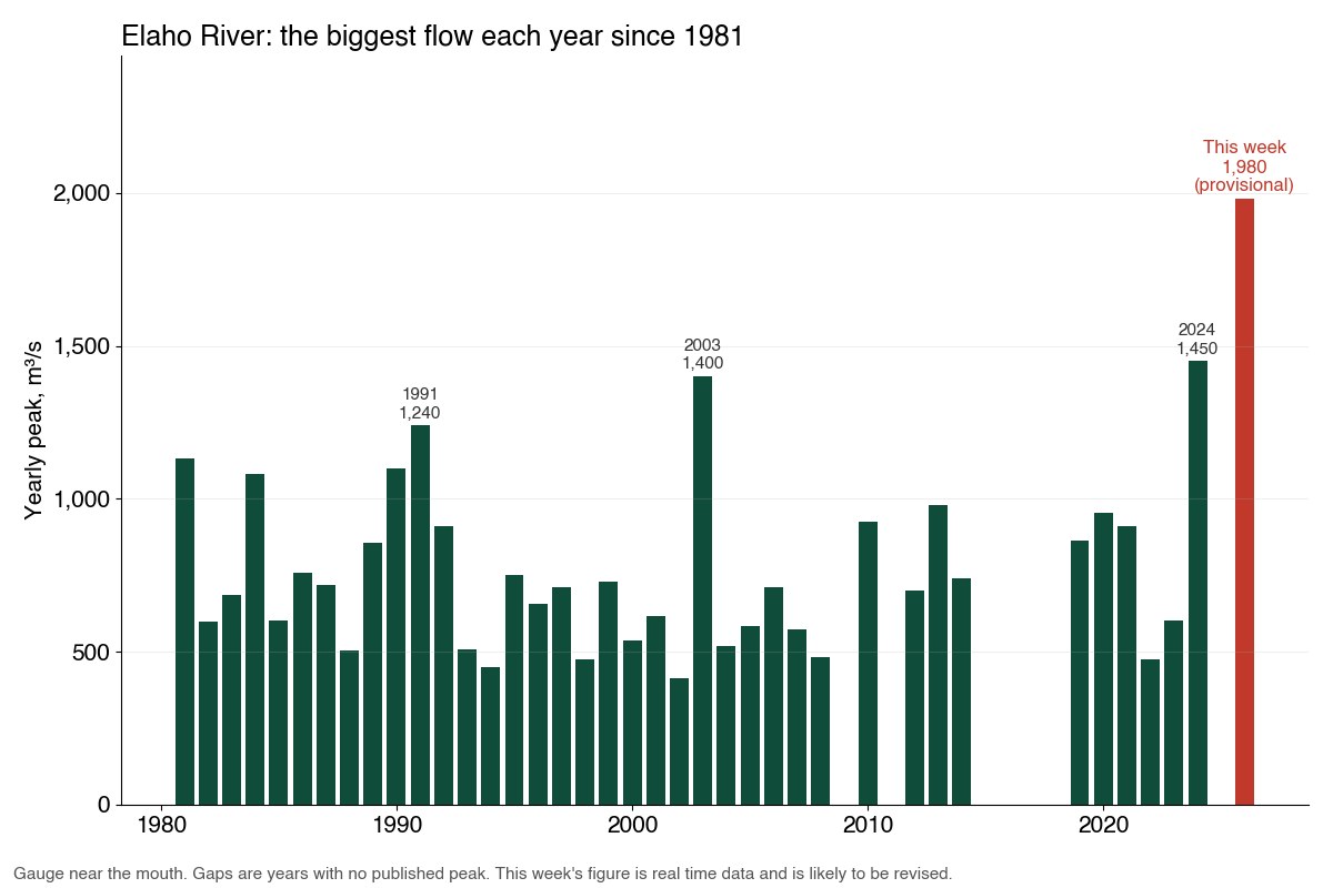
- Elaho137%About 1,980 at 3:20 a.m. Thursday. Highest published yearly peak 1,450, January 2024. Provisional and likely to be revised.
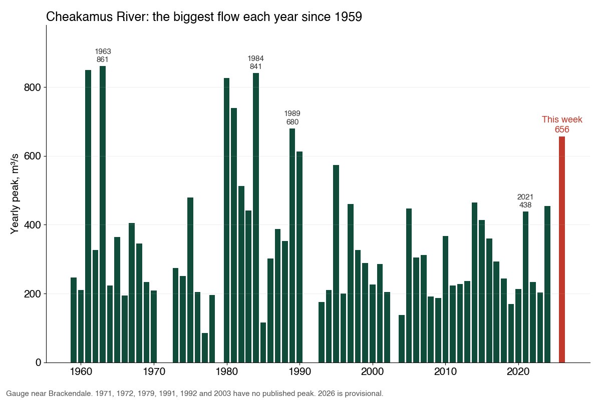
- Cheakamus76%656 at 7:55 a.m. Thursday, beside Paradise Valley. Highest published peak 861, in 1963. Highest published peak since 1989.
- Squamish75%2,370 at 10:55 a.m. Thursday. Record 3,140, October 2003. Fourth biggest since 1958.
Peaks in cubic metres per second, from provisional real time data. Red edge: the highest published yearly peak.
- Elaho River, near its mouth: about 1,980 at 3:20 a.m. Thursday. The highest yearly peak in its published record, which goes back to 1981 with some years missing, is 1,450, from January 2024. The water level, 8.31 metres, was also above every published yearly peak level (2012 to 2024, with 2015 missing). Treat the exact flow with care: at a flow this far past anything measured, it is estimated from the water level and is likely to be revised. It was very likely a record. By how much is less certain.
- Cheakamus River, near Brackendale, the river beside Paradise Valley: 656 at 7:55 a.m., its highest since 1989, when it peaked at 680. No peak was published for 1991, 1992 or 2003, and 1991 and 2003 were two of the three biggest Squamish River floods on record. It is half again the 2021 peak of 438, which put Paradise Valley on evacuation alert, and about 25 times a typical November flow of 25.8.
- Squamish River, near Brackendale: 2,370 at 10:55 a.m. That is past the province's 1 in 10 year flood size (2,129), which means about a 1 in 10 chance of a flood that big in any year, and short of 1 in 20 (2,441). It would be the fourth biggest published yearly peak since 1958 (seven years have none), and the biggest since 2003.
Every big Squamish River flood on record, and the Cheakamus history2003 tops the Squamish list at 3,140. Thursday's 2,370 would be fourth.
Squamish River, yearly peaks at the gauge near Brackendale, in cubic metres per second (Water Survey of Canada, since 1958, seven years missing):
- 1. October 18, 2003: 3,140
- 2. October 8, 1984: 2,610
- 3. August 30, 1991: 2,460
- 4. November 12, 2026 (provisional): 2,370
- 5. November 1, 1981: 2,270
- 6. December 27, 1980: 2,180
- 7. September 20, 2015: 2,080
- 8. November 12, 1990: 2,060
- 9. January 30, 2024: 2,010
- 10. November 5, 1975: 1,950
Cheakamus River, published yearly peaks higher than this week's 656: 861 (1963), 850 (1961, estimated), 841 (1984), 827 (1980), 739 (1981) and 680 (1989).
How the night unfolded
All times Pacific, Thursday, November 12, unless noted.
- Wednesday, 7 to 8 p.m.: the Elaho jumps from about 1,100 to 1,310 in an hour and keeps climbing.
- 3:20 a.m.: the Elaho peaks near 1,980.
- About 5 a.m.: the release from the Cheakamus Dam peaks, the District said.
- 7:55 a.m.: the Cheakamus near Brackendale peaks at 656.
- Morning: the rainfall warning ends.
- 10:55 a.m.: the Squamish River peaks near 2,370, almost exactly what the province forecast on Tuesday (about 2,360 near 9 a.m. Thursday).
- By Thursday afternoon: the District has opened its Emergency Operations Centre, the Squamish Nation has opened one too, close to 40 Nation members have been evacuated and Paradise Valley is under the shelter in place advisory.
Why the Cheakamus ran so much higher than Monday's forecast
On Monday, three days ahead, the province's river model had the Cheakamus near Brackendale peaking around 393 on Thursday afternoon. It reached 656, about two thirds more, and hours earlier. The Squamish forecast, by contrast, was almost exact.
Two things feed that gauge: water BC Hydro lets out of Daisy Lake at the Cheakamus Dam, and rain on the creeks that join below the dam. BC Hydro had not published Thursday's release when we checked, so we cannot yet say how much of the gap came from each.
How much rain fell122 mm at the Squamish Airport on Wednesday alone, 265 mm in a week
- Squamish Airport, day by day (Environment Canada): 72 mm from Thursday to Saturday last week, then 34 mm Sunday, 9 mm Monday, 28 mm Tuesday and 122 mm Wednesday. That is 265 mm in seven days.
- The 48 hours to Thursday morning: 134 mm in Squamish, 140 mm at Porteau Cove and 138 mm in Whistler, Environment Canada said. Meteorologist Jason Ross put the storm's total at the Squamish Airport at 160 mm, the Chief reported. Port Mellon, across Howe Sound, had 306 mm since Tuesday.
- It was warm. Wednesday reached 13.9°C at the airport. Over the headwaters the Open-Meteo model put the freezing level near 2,860 metres early Wednesday, so most of the watershed got rain rather than snow.
Around the corridor
- Pemberton: the whole village is under an evacuation alert, with an evacuation order for properties on Airport Road. Highway 99 east of Pemberton was closed both ways, the Canadian Press reported.
- In town: pumps at Harris Slough are moving water away from neighbouring properties, the Chief reported. On Wednesday the District asked residents to save water because high flows were affecting the wastewater treatment plant.
Last time Paradise Valley flooded
- November 2021: the regional district put 35 properties in Upper Paradise Valley, along Paradise Valley Road and Mistys Lane, on evacuation alert, and BC Hydro issued a spill notice for the Cheakamus Dam (Squamish Reporter). The Cheakamus peaked at 438 that year.
- January 2024: floodwater covered Squamish Valley Road (CTV News), with the Squamish River at about 2,010.
- October 2003, the record: about 100 people were ordered out of their homes and about 200 more left the next day (CBC News).
More on how Squamish manages flood risk is on our flood protection page.
Getting help
- Emergency or a downed power line: 911
- Squamish Nation Public Safety Line, flooding: 604-982-9938, 24 hours a day, or public_safety@squamish.net. It can also connect members to outreach and the crisis response team.
- Squamish Nation Wellness team: 604-982-7816 or wellness@squamish.net. Healthy Hubs at 1221 Chief Billy Drive and 41139-B Government Road.
- District of Squamish emergency centre, about the Paradise Valley advisory: 778-655-3020
- District public works, flooding in town: 604-815-6868, after hours 604-815-4040
- Squamish Lillooet Regional District: 1-800-298-7753. Medical, mobility or transport needs: call its emergency centre early at 604-384-7357.
- If you had to leave home: register for Emergency Support Services at ess.gov.bc.ca, or call the Canadian Red Cross at 1-888-800-6493. Squamish Nation members can also call the Public Safety Line.
- Alerts: the Nation's Voyent Alert!, the District's Squamish Alert and the regional district's SLRD Alert
- Roads: DriveBC, 1-800-550-4997. River levels: our Today page.
The Nation says it will keep updating its post. We will update this story as things change.